Surface displacement grids
We provided 3-D displacement maps due to various atmospheric, oceanic and hydrological
loading. The displacements are provided in the
Center of Figure (CF) & in the
Center of Mass (CM) reference frame in both ascii and netcdf
format.
We use a land/sea mask model at 0.05-degree resolution for all the different loading computations, derived from the GMT
(Generic Mapping Tools) database.
1. Operationnal products
- ATMIB: atmospheric loading estimated from surface pressure from ECMWF
operational model (3 hours), assuming an inverted barometer ocean
response to pressure forcing.
- ERA5_IB: atmospheric loading estimated from surface pressure from latest
ECMWF Reanalysis (ERA5) (1 hour), assuming an inverted barometer ocean
response to pressure forcing.
- ECCO2: non-tidal ocean loading estimated from ECCO2 (Menemenlis et al., 2008) ocean bottom
pressure (daily, 0.25 degree).
2. Old products (no more updates)
- ATMMO: atmospheric loading estimated from surface pressure from ECMWF
operational model (3 hours), assuming a dynamic ocean response to
pressure & winds from TUGO-m barotropic model (Carrere &
Lyard, 2003) (3 hour & 0.25 degree).
- ERAin: atmospheric loading estimated from surface pressure from ERA interim
(ECMWF Reanalysis) model (6 hours), assuming an inverted barometer ocean
response to pressure forcing,
- ERAhyd: hydrology loading (soil-moisture and snow) estimated from ERA interim
- GLDAS1: hydrological loading (soil moisture, snow and canopy water) from
GLDAS1 model (Rodell et al., 2004).
- ECCO: non-tidal ocean loading estimated from ECCO1 (kf080i) (Wunch et al., 2009) ocean bottom
pressure (12 hours, about 1 degree).
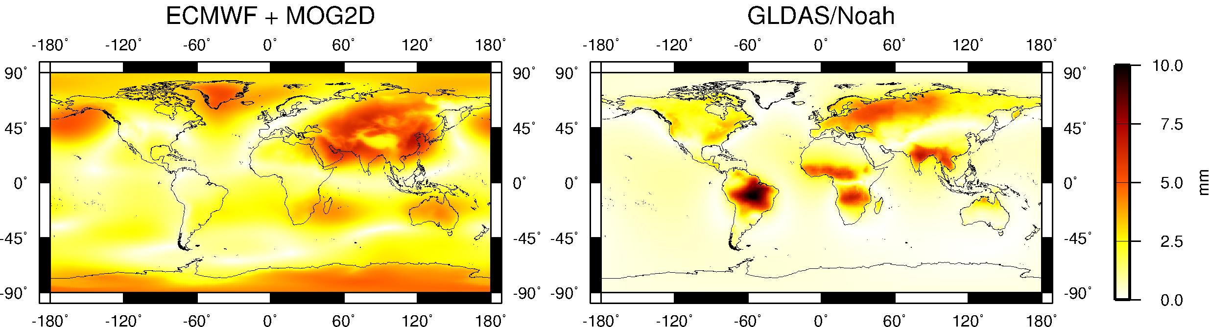
Figure 1: Annual vertical
displacements due to atmospheric (ECMWF) and induced oceanic (TUGO-m)
(left) and hydrological (GLDAS/Noah) (right) loading effects in the
Center of Figure (CF) reference frame.
Careful: As TUGO-m model is forced not only
by atmospheric pressure but also by surface winds, loading estimates
from classical ocean general circulation model
(such as ECCO) should not be added to the (ECMWF+TUGO-m) loading computations.